Elite Wall Decor
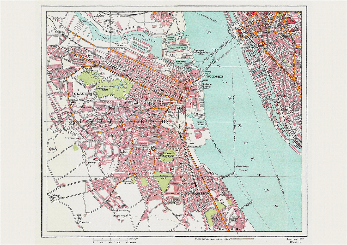
Liverpool in 1928 Series - showing Birkenhead area (Liv1928-16)
Liverpool in 1928 Series - showing Birkenhead area (Liv1928-16)
Couldn't load pickup availability
This digital download is a high-quality 300dpi JPG image of a street atlas map dated 1928. It is enlarged, and sized to print if required at A2 dimensions (59.4 cm x 42 cm), making it perfect for framing or use in a project. Or simply view it in close up on your computer screen using Windows Photo or similar.
This series of 1928 maps of Liverpool shows (where present) roads, farms, public buildings (such as hospitals, libraries, town halls, churches, schools, colleges, museums, gas works, sewage works, etc.) , larger houses, woods, rivers, estates and parks. They also show footpaths, ponds and lakes.
These maps are sharp and clear. All railway lines and stations are shown and named.
Birkenhead, located just across the River Mersey from Liverpool, was a bustling town with a rich history in 1928. The town had grown rapidly during the Industrial Revolution, thanks to its strategic location on the river and its proximity to the city of Liverpool.
One of the most significant landmarks in Birkenhead was the Birkenhead Town Hall, which had been built in the mid-19th century and was an impressive example of Victorian architecture. It was home to the town's council and was a hub of activity and civic pride.
Another historical place of interest was the Birkenhead Park, which had been designed by the famous landscape architect Joseph Paxton in the mid-19th century. It was one of the first publicly-funded parks in the world and was a popular destination for locals and visitors alike.
Birkenhead was also home to a number of notable churches, including the Birkenhead Priory, which had been established in the 12th century and was one of the oldest surviving buildings in the town. It had served as a place of worship, a hospital, and a fortress over the centuries and was a fascinating example of the town's medieval history.
In addition to these landmarks, Birkenhead was also home to a variety of businesses and industries, including shipbuilding, glassmaking, and pottery. The Cammell Laird shipyard, located in the heart of the town, was one of the largest and most important shipyards in the world and played a crucial role in the town's economy.
Overall, Birkenhead was a town with a rich and fascinating history, filled with impressive architecture, beautiful parks, and a variety of businesses and industries. It was a testament to the growth and development of the region during the Industrial Revolution and a source of pride for its residents.
Whether you're a history buff, a cartography enthusiast, or simply looking for a unique piece of decor for your home or office, this map is sure to delight. It's a piece of history that you can own and enjoy for years to come.