Elite Wall Decor
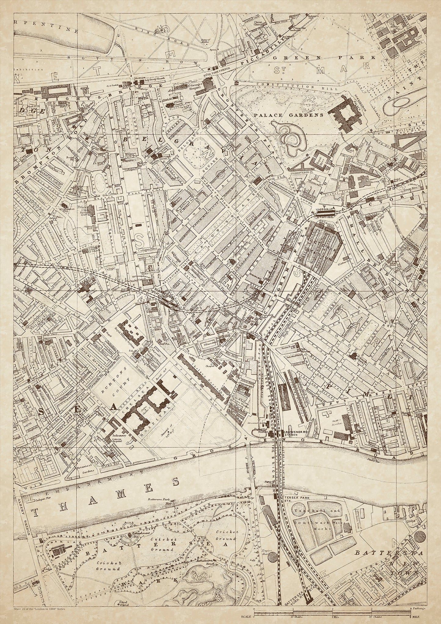
London in 1888 Series - showing Belgravia, Chelsea, Pimlico, Battersea (north), Buckingham Palace - sheet 22
London in 1888 Series - showing Belgravia, Chelsea, Pimlico, Battersea (north), Buckingham Palace - sheet 22
Couldn't load pickup availability
Also shows: Brompton Road, Knightsbridge, Piccadilly, Green Park, Sloane Street, Hyde Park Corner, Victoria Station, Watney's Brewery, Royal Military Asylum, Chelsea Hospital, Chelsea Barracks, Albert Bridge, Victoria Bridge, Battersea Park (north), Vauxhall & Southwark Water Works.
This digital download is a high-quality 300dpi JPG image of a London street atlas map dated 1888. It is enlarged, and sized to print if required at A1 dimensions (84.1 cm x 59.4 cm), or simply view it in close up on your computer screen using for instance Windows Photo or similar. These maps are sharp and clear. All railway lines and stations are shown and named.
Belgravia, Chelsea, Pimlico, and Battersea (north) were all prestigious neighborhoods in London in 1888. Belgravia was known for its grand townhouses and elegant streets, while Chelsea had a more bohemian and artistic vibe. Pimlico was a popular area for the middle class, with rows of terraced houses and tree-lined streets. Battersea, on the other hand, was a more industrial area with factories and warehouses.
Buckingham Palace, the residence of the British monarch, was a major landmark in the area, as was Victoria Station, one of London's busiest railway stations. Brompton Road and Knightsbridge were popular shopping destinations, with luxury department stores and boutiques.
Green Park and Hyde Park Corner were popular areas for recreation and relaxation, while Albert Bridge and Victoria Bridge were important river crossings. Battersea Park (north) was a popular park for leisure and sports.
Watney's Brewery was a major brewery in the area, and the Royal Military Asylum and Chelsea Barracks were both military institutions.
The Victoria and Southwark Water Works provided clean drinking water to the area.
Whether you're a history buff, a cartography enthusiast, or simply looking for a unique piece of decor for your home or office, this map is sure to delight. It's a piece of history that you can own and enjoy for years to come.