Elite Wall Decor
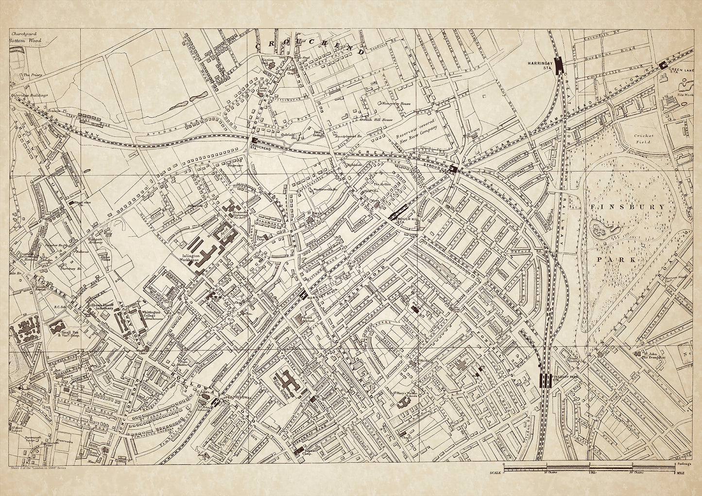
London in 1888 Series - showing Crouch End, Highgate Hill, Finsbury Park - sheet 2
London in 1888 Series - showing Crouch End, Highgate Hill, Finsbury Park - sheet 2
Couldn't load pickup availability
Also shows: Archway Road, Holloway Road, Hornsey Rise, Crouchend Station, West London Union Workhouse, Islington Workhouse, Whittington College, Hornsey Rise Asylum, Alexandra orphanage, Harringay Station, Stroud Green Station, Green Lane Station, Finsbury Park Station, St. Mary's Workhouse Schools
This digital download is a high-quality 300dpi JPG image of a London street atlas map dated 1888. It is enlarged, and sized to print if required at A1 dimensions (84.1 cm x 59.4 cm), or simply view it in close up on your computer screen using for instance Windows Photo or similar. These maps are sharp and clear. All railway lines and stations are shown and named.
In 1888, the areas of Crouch End, Highgate Hill, Finsbury Park, Archway Road, Holloway Road, Hornsey Rise, and the surrounding areas were inhabited by a mix of working-class and middle-class residents.
Crouch End was a relatively new suburb, developed in the mid-19th century for the expanding middle-class population. The area was known for its green spaces, including Crouch Hill Park and Priory Park. Crouch End Station, which opened in 1867, provided easy access to central London.
Highgate Hill was also an affluent area, with many large houses and mansions occupied by wealthy families. The area was known for its stunning views of London and its proximity to Hampstead Heath.
Finsbury Park, located in the borough of Islington, was a working-class area with a mix of industrial and residential buildings. Finsbury Park Station, which opened in 1861, provided easy access to the city for workers.
Archway Road was a busy thoroughfare connecting Highgate to the city. It was lined with shops, pubs, and restaurants, and served as a major route for travelers and commuters.
Hornsey Rise was a working-class area, with many of its residents employed in the nearby factories and workshops. The area was also home to several institutions, including the West London Union Workhouse and the Hornsey Rise Asylum.
Crouchend Station and Stroud Green Station provided easy access to central London for residents of the area.
The Whittington College, named after the famous Dick Whittington, was a charitable institution that provided education and training for young women from poor families.
St. Mary's Workhouse Schools, located in Islington, provided education and training for poor children from the area.
The Alexandra Orphanage, located in Hornsey, provided care for orphaned and destitute children.
Whether you're a history buff, a cartography enthusiast, or simply looking for a unique piece of decor for your home or office, this map is sure to delight. It's a piece of history that you can own and enjoy for years to come.