Elite Wall Decor
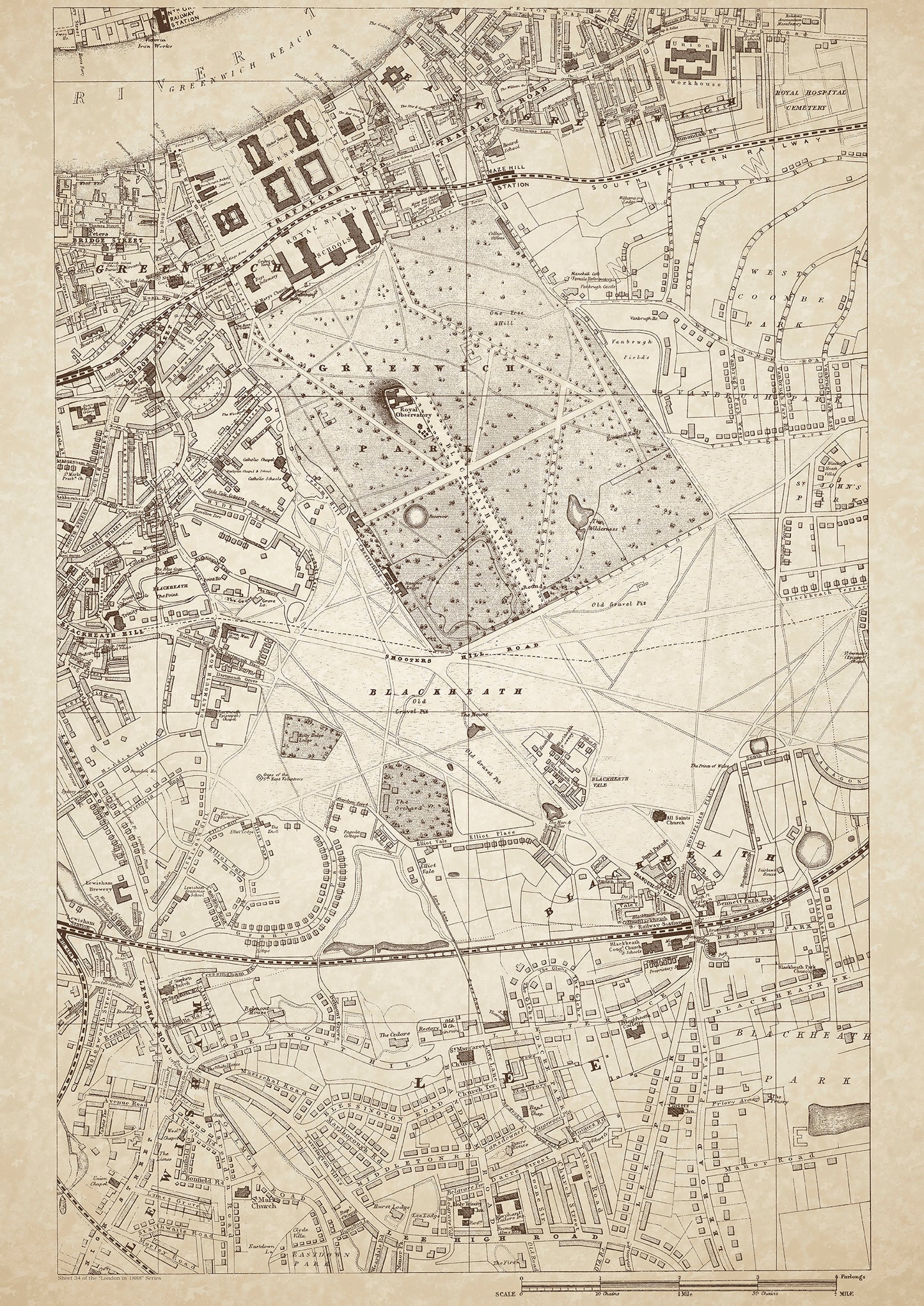
London in 1888 Series - showing Greenwich, Lewisham, Blackheath, Lee - sheet 34
London in 1888 Series - showing Greenwich, Lewisham, Blackheath, Lee - sheet 34
Couldn't load pickup availability
Also shows: Greenwich Hospital, East Greenwich, Greenwich Park, Greenwich Union Workhouse, Vanbrugh Park, St. John's Park (west), West Coombe Park, Belmont Hill, Blackheath Park.
This digital download is a high-quality 300dpi JPG image of a London street atlas map dated 1888. It is enlarged, and sized to print if required at A1 dimensions (84.1 cm x 59.4 cm), or simply view it in close up on your computer screen using for instance Windows Photo or similar. These maps are sharp and clear. All railway lines and stations are shown and named.
Greenwich, Lewisham, Blackheath, and Lee were all suburbs located in the southeast of London in 1888. Greenwich was a royal borough and the site of the Greenwich Observatory, which played a crucial role in determining the world's time zones. The town was home to many affluent families, including naval officers, aristocrats, and wealthy merchants.
The Greenwich Hospital, originally built as a retirement home for seamen, had become a school for the sons of naval officers. It was also home to a naval museum and had a beautiful chapel. The East Greenwich area was mostly industrial, with factories, warehouses, and shipyards.
Greenwich Park, one of London's largest parks, was a popular destination for both locals and tourists. The park offered stunning views of the city, and visitors could explore the Royal Observatory and the National Maritime Museum.
Lewisham was a bustling market town with a mix of industrial and residential areas. The Lewisham Workhouse provided relief to the poor and destitute, while St. John's Park and West Coombe Park were affluent residential areas.
Blackheath was a wealthy residential suburb with many large houses and estates. Belmont Hill was particularly notable for its grand villas, while Blackheath Park was a popular area for well-to-do families.
Lee was a mix of residential and industrial areas, with a notable gasworks located there. The area had become more prosperous in recent years, with many middle-class families moving in.
New Cross Road was a busy commercial hub that connected the southeast suburbs to the city center. The London Brighton & South Coast Railway Station and Railway Workshops, Nunhead Station, and Deptford Junction Station were all major transport hubs that allowed residents to travel to and from the city center easily.
Whether you're a history buff, a cartography enthusiast, or simply looking for a unique piece of decor for your home or office, this map is sure to delight. It's a piece of history that you can own and enjoy for years to come.