Elite Wall Decor
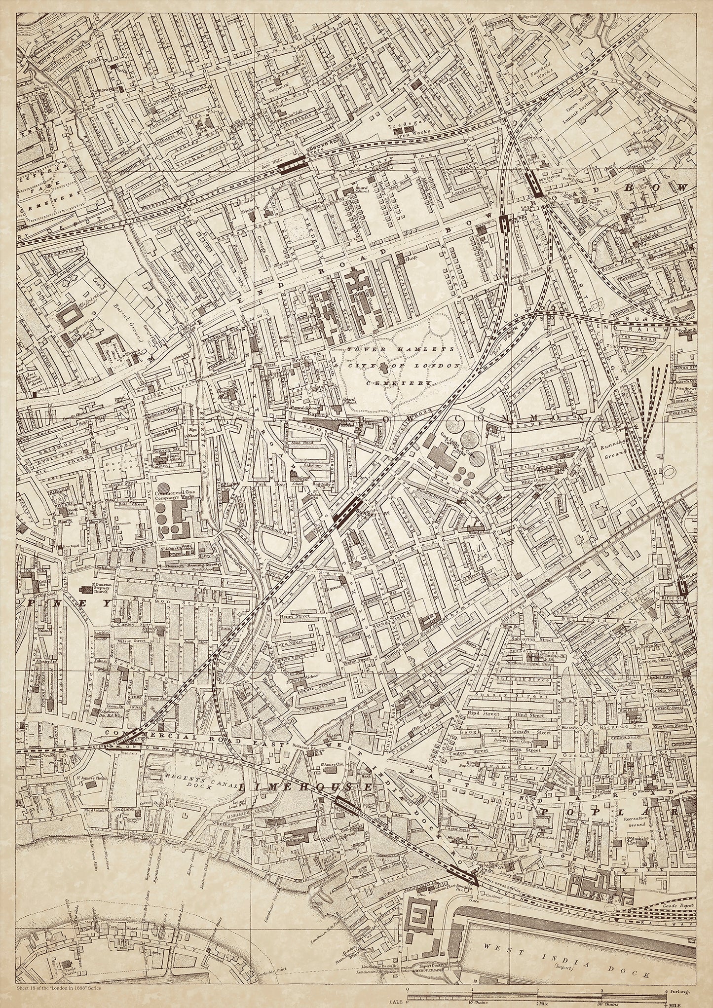
London in 1888 Series - showing Mile End Road, Limehouse, Poplar, Stepney (east) - sheet 18
London in 1888 Series - showing Mile End Road, Limehouse, Poplar, Stepney (east) - sheet 18
Couldn't load pickup availability
Also shows: Mile End Old Town Workhouse, Whitechapel Union Workhouse, City Union Workhouse, Victoria Park Cemetery, Grove Hall Lunatic Asylum, Coborn Road Station, Bow Station, Bow Road Station, Tredegar Iron Works, Tower Hamlets City of London Cemetery, Limehouse Workhouse, Poplar Workhouse, eastern Commercial Road East, West India Dock Road, East India Dock Road, Regents Canal Dock, northwest part of, West India Dock, Stepney Station, Burdett Road Station, Limehouse Station, East India Docks Station, South Bromley Station.
This digital download is a high-quality 300dpi JPG image of a London street atlas map dated 1888. It is enlarged, and sized to print if required at A1 dimensions (84.1 cm x 59.4 cm), or simply view it in close up on your computer screen using for instance Windows Photo or similar. These maps are sharp and clear. All railway lines and stations are shown and named.
Mile End Road, Limehouse, Poplar, and Stepney in the east of London were bustling areas in 1888, with a diverse mix of people, including the working class, immigrants, and the impoverished. The Mile End Old Town Workhouse, Whitechapel Union Workhouse, and City Union Workhouse were all located in this area, providing relief for the destitute.
Victoria Park Cemetery and Tower Hamlets City of London Cemetery were notable burial grounds in the area, while the Grove Hall Lunatic Asylum provided care for the mentally ill.
The Tredegar Iron Works, located in Bow, was a major employer in the area and a hub of industrial activity. Nearby stations, including Coborn Road Station, Bow Station, and Bow Road Station, provided transportation for workers and residents.
The West India Dock Road, East India Dock Road, and Regent's Canal Dock were all important waterways for trade and commerce, with the northwest part of West India Dock serving as a major port. The Limehouse, Poplar, and Eastern Commercial Road East areas were known for their proximity to the docks and maritime industries.
The Limehouse Workhouse and Poplar Workhouse provided support for those in need, while Stepney Station, Burdett Road Station, Limehouse Station, East India Docks Station, and South Bromley Station offered convenient transportation options for locals and visitors alike. Unfortunately, the area was also the hunting ground of Jack the Ripper, who terrorized the streets of Whitechapel in 1888, making it a notorious part of London's history.
Whether you're a history buff, a cartography enthusiast, or simply looking for a unique piece of decor for your home or office, this map is sure to delight. It's a piece of history that you can own and enjoy for years to come.