Elite Wall Decor
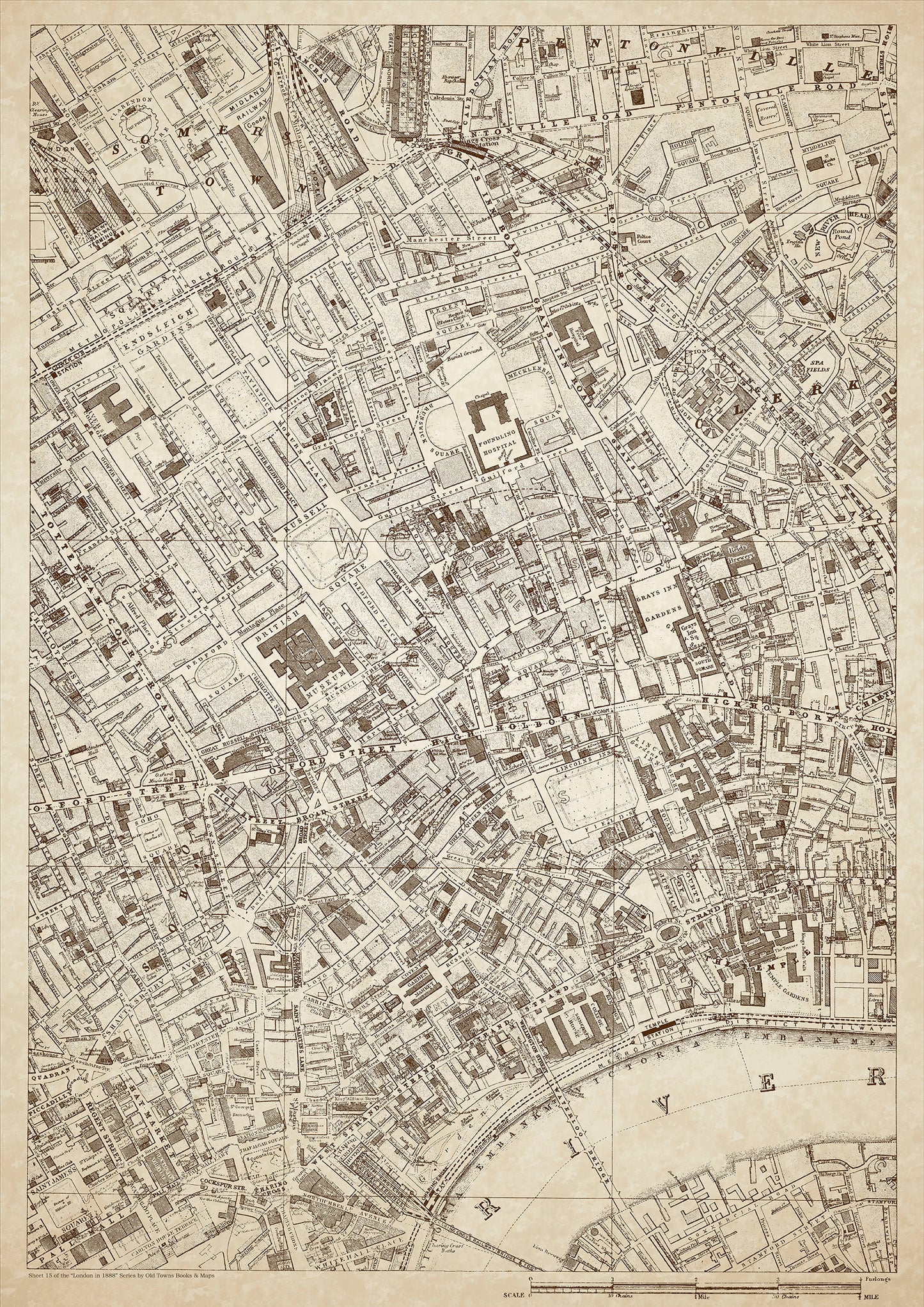
London in 1888 Series - showing Somers Town, Clerkenwell, Covent Garden - sheet 15
London in 1888 Series - showing Somers Town, Clerkenwell, Covent Garden - sheet 15
Couldn't load pickup availability
Also shows: Grays Inn Road, Pentonville Road, Euston Road, Foundling Hospital, Royal Free Hospital, Regent Square, Russell Square, Endsleigh Gardens, The Temple, Oxford Street (east), High Holborn, the Strand, Victoria Embankment, Lincolns Inn Fields, Soho Square, Charing Cross, Covent Garden Market.
This digital download is a high-quality 300dpi JPG image of a London street atlas map dated 1888. It is enlarged, and sized to print if required at A1 dimensions (84.1 cm x 59.4 cm), or simply view it in close up on your computer screen using for instance Windows Photo or similar. These maps are sharp and clear. All railway lines and stations are shown and named.
Somers Town, located in the London Borough of Camden, was a working-class district in 1888. The area was densely populated, and many of the residents were employed in the nearby railway yards, factories, and warehouses.
Clerkenwell was another industrial district, home to many small factories and workshops. The area was also known for its breweries and distilleries. Many of the residents were skilled craftsmen or tradespeople.
Covent Garden was a bustling commercial district, known for its large covered market. The area was home to many merchants, traders, and shopkeepers, as well as a thriving theatre scene.
Grays Inn Road and Pentonville Road were major thoroughfares in the area, connecting the district to other parts of London. Euston Road was also an important road, connecting the area to King's Cross and other parts of North London.
The Foundling Hospital was located in the area, a charitable institution established in the 18th century to care for abandoned children. The Royal Free Hospital was also located nearby, a teaching hospital that provided medical care to the local community.
Regent Square and Russell Square were prominent garden squares in the area, surrounded by grand Georgian townhouses. Endsleigh Gardens was a newer development, consisting of large terraced houses.
The Temple was a historic area located on the banks of the River Thames, home to the legal profession and the Inns of Court. It was a popular destination for tourists and visitors.
Oxford Street (east), High Holborn, the Strand, and Victoria Embankment were major thoroughfares in the area, lined with shops, businesses, and entertainment venues.
Lincoln's Inn Fields was a large public park, surrounded by grand Georgian townhouses. Soho Square was another garden square in the area, surrounded by restaurants, cafes, and shops.
Charing Cross was a major transport hub, with a railway station and a busy street market. Covent Garden Market was a major commercial center, home to hundreds of vendors selling fresh produce, meat, fish, and flowers.
Whether you're a history buff, a cartography enthusiast, or simply looking for a unique piece of decor for your home or office, this map is sure to delight. It's a piece of history that you can own and enjoy for years to come.