Elite Wall Decor
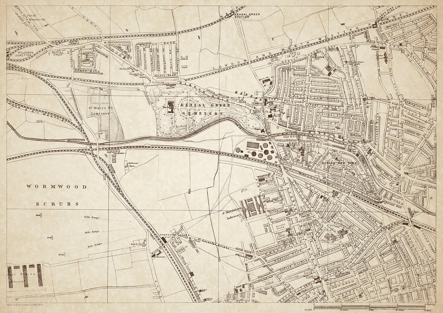
London in 1888 Series - showing Wormwood Scrubs, Kensal Green, Kensal New Town - sheet 12
London in 1888 Series - showing Wormwood Scrubs, Kensal Green, Kensal New Town - sheet 12
Couldn't load pickup availability
Also shows: St Mary's RC Cemetery, Kensal Green Cemetery, Willesden Junction, St. Marylebone Infirmary, Notting Hill Station.
This digital download is a high-quality 300dpi JPG image of a London street atlas map dated 1888. It is enlarged, and sized to print if required at A1 dimensions (84.1 cm x 59.4 cm), or simply view it in close up on your computer screen using for instance Windows Photo or similar. These maps are sharp and clear. All railway lines and stations are shown and named.
In 1888, Wormwood Scrubs was primarily an open space, which was used for various purposes including military training, public executions, and as a site for the construction of the nearby HM Prison Wormwood Scrubs. The area of Kensal Green was known for its famous cemetery, Kensal Green Cemetery, which was established in the 1830s and is the final resting place of many notable figures in British history, including William Makepeace Thackeray and Isambard Kingdom Brunel. Kensal New Town was a new residential area developed in the late 19th century, attracting a mix of working-class and middle-class residents.
St Mary's RC Cemetery, located in Kensal Green, was a Catholic cemetery that served the growing Catholic population in the area. Willesden Junction was a major transportation hub, connecting several railway lines and providing access to central London. St. Marylebone Infirmary, also known as St. Mary's Hospital, was a significant healthcare institution that provided medical care to the poor and working-class residents of the area. Notting Hill Station was a railway station that served the affluent residential area of Notting Hill.
The class of people in this area was quite diverse, ranging from the working-class residents in Kensal New Town and Wormwood Scrubs to the more affluent middle and upper-class residents in Notting Hill and Kensal Green. The area also had a significant Catholic population, reflected in the presence of St Mary's RC Cemetery and the St Marylebone Infirmary. The transportation hub at Willesden Junction also made the area accessible to commuters from other parts of London.
Whether you're a history buff, a cartography enthusiast, or simply looking for a unique piece of decor for your home or office, this map is sure to delight. It's a piece of history that you can own and enjoy for years to come.