Elite Wall Decor
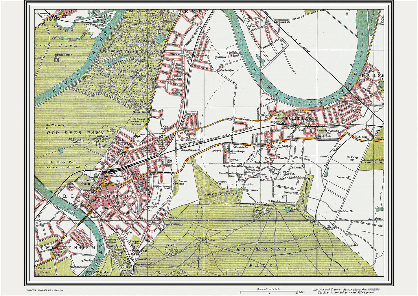
London in 1908 Series - showing Richmond, Mortlake area (Lon1908-20)
London in 1908 Series - showing Richmond, Mortlake area (Lon1908-20)
Couldn't load pickup availability
This digital download is a high-quality 300dpi JPG image of a street atlas map dated 1908. It is enlarged, and sized to print if required at A2 dimensions (59.4 cm x 42 cm), making it perfect for framing or use in a project. Or simply view it in close up on your computer screen using Windows Photo or similar.
This series of 1908 maps of London shows (where present) roads, farms, public buildings (such as hospitals, libraries, town halls, churches, schools, colleges, museums, gas works, sewage works, etc.) , larger houses, woods, rivers, estates and parks. They also show footpaths, ponds and lakes.
These maps are sharp and clear. All railway lines and stations are shown and named.
Richmond and Mortlake, located in southwest London, were well-known for their scenic beauty and historical significance in 1908.
Richmond was a thriving market town with a population of around 27,000 people. The town had a rich history, dating back to the Tudor period, and was known for its picturesque setting on the banks of the River Thames. The town's most prominent landmark was the magnificent Richmond Palace, which was once the residence of King Henry VIII. The palace had fallen into disrepair by 1908 and was no longer open to the public, but it still held an important place in the town's history.
There were several notable churches in Richmond, including St Mary Magdalene's Church, which was located near the river and had a beautiful 18th-century organ. Another church of note was St. Anne's Church, which had been built in the 18th century and was known for its ornate stonework and stained glass windows.
Mortlake was a small village located just south of Richmond, known for its connections to the famous 17th-century diarist Samuel Pepys. Pepys had lived in the village for a time and had attended St Mary's Church, which still stood in the village in 1908. The church was known for its ancient Norman architecture and had a small museum dedicated to Pepys.
One of the main attractions in the area was the Kew Gardens, a botanical garden that had been established in the 18th century. The gardens had an extensive collection of plants and were considered one of the most important scientific institutions in the world. The Royal Botanic Gardens at Kew was also a popular tourist attraction, drawing visitors from all over the world.
Overall, Richmond and Mortlake were known for their historic buildings, stunning natural beauty, and cultural significance in London.
Whether you're a history buff, a cartography enthusiast, or simply looking for a unique piece of decor for your home or office, this map is sure to delight. It's a piece of history that you can own and enjoy for years to come.