Elite Wall Decor
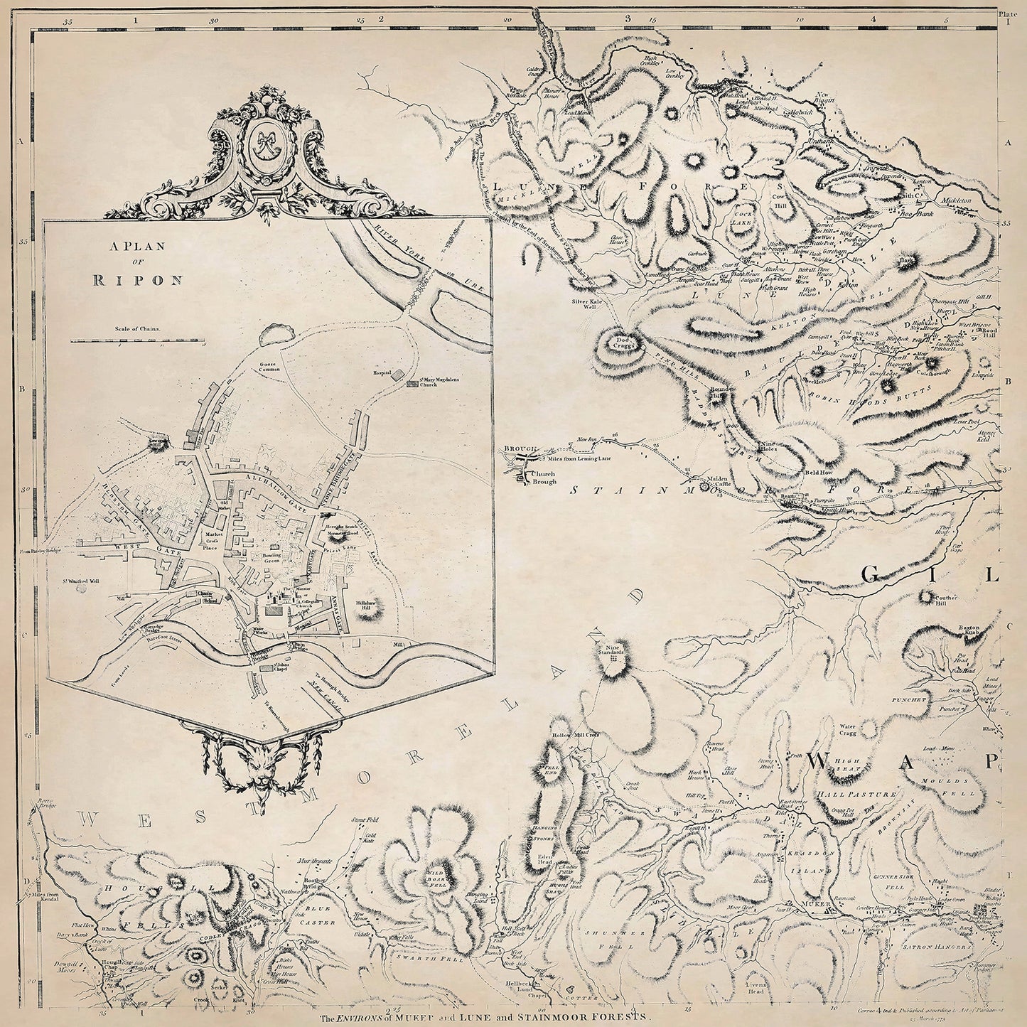
Yorkshire in 1771 sheet 1-1 - features a plan of Ripon, and shows the Newbiggin, Mickleton, Muker, Lune Forest, Stainmoor Forest area
Yorkshire in 1771 sheet 1-1 - features a plan of Ripon, and shows the Newbiggin, Mickleton, Muker, Lune Forest, Stainmoor Forest area
Couldn't load pickup availability
Downloading this large file to phones or tablets is not recommended
This digital download is a high-quality 300dpi JPG image of one sheet from Thomas Jefferys "The County of York Survey'd" published in 1771. The image is crisp, clear and easy to read. It measures 60 x 60 cm, or 7087 x 7087 pixels but can be cropped or resized with the appropriate software. Download now to print whole or in part at home, or simply view it in close up on your device using image software such as Adobe Photoshop, Gimp, Windows Photo, or similar.
RIPON:
In the late 18th century, the town of Ripon in Yorkshire was a bustling and prosperous market town with a rich history.
Ripon's economy was diverse, with a range of industries supporting the town and its surrounding areas. Agriculture played a significant role, with farmers cultivating crops such as wheat, barley, oats, and vegetables. They also reared livestock, including cattle, sheep, and pigs.
The town market attracted traders and merchants from the surrounding countryside. This created employment opportunities for individuals involved in trade and commerce, such as merchants, shopkeepers, and craftsmen. Blacksmiths, carpenters, and other skilled artisans also found work in Ripon, providing essential services to the local community.
Ripon was known for its textile industry, with several mills operating along the River Skell and its tributaries. These mills focused on processing wool and producing textiles, including woolen cloth and worsted fabric. The textile industry employed spinners, weavers, dyers, and other workers involved in the manufacturing process.
Another notable industry in Ripon was brewing. The town had several breweries producing ale and beer, which served as a source of employment for brewers, coopers, and other brewery workers. Ripon's access to local water sources and its strategic position as a market town contributed to the success of its brewing industry.
Ripon Cathedral, also known as Ripon Minster, was a significant landmark and a center of religious and cultural life in the town. The cathedral, with its imposing architecture and rich history, attracted visitors and pilgrims.
The Spa Baths in Ripon were popular during this period. The spa waters were believed to have healing properties, and people would visit for relaxation and medicinal purposes.
Ripon Racecourse, established in the late 17th century, continued to be a hub of horse racing and equestrian events in the late 18th century. The racecourse attracted crowds and brought economic activity to the town.
In addition to these specific items of interest, Ripon's town center featured a mix of Georgian and medieval architecture, with charming streets, market squares, and historic buildings.
The environs of Newbiggin, Mickleton, Muker, Lune Forest, Stainmoor Forest:
During the late 18th century, the landscape of Newbiggin, Mickleton, Muker, Lune Forest, and Stainmoor Forest in Yorkshire was predominantly rural, characterized by rolling hills, open moorland, and picturesque valleys. These areas were primarily agricultural, with farming being the main occupation for the local population. The region was known for its rich farmland and the rearing of livestock.
In terms of local jobs and occupations, the majority of people in these areas would have been engaged in agricultural activities. Farmers cultivated crops such as wheat, barley, oats, and turnips, while also raising cattle, sheep, and horses. The farmers and their families worked on their own lands or as laborers on large estates.
Some notable industries of the period included mining and quarrying. The region had significant mineral resources, including lead and coal. Mining operations were particularly prominent in Lune Forest, where lead mines provided employment to many workers. Quarrying activities were also common, with the extraction of limestone and other building materials for local construction purposes.
In terms of interesting buildings and estates, the late 18th century saw the existence of several notable structures in the region. Muker, for example, had a charming village green surrounded by traditional stone-built cottages. In Mickleton, St. Lawrence Church stood as a prominent landmark, showcasing fine architecture and historical significance.
In Newbiggin, the most notable estate was Newbiggin Hall, a grand manor house that was the residence of the local gentry. It featured elegant gardens, extensive farmland, and employed a significant number of staff, including gardeners, housekeepers, and domestic servants.
Stainmoor Forest, situated on the eastern edge of the Yorkshire Dales, was known for its dense woodland, which provided timber for local construction and fuel. The forest also served as a hunting ground for the local nobility and offered employment to gamekeepers and forest workers.